

PROJECT #050: 2048 MELBOURNE TRAM MAP
Back in 1923, about 60 years before I was even a “planning proposal”, someone had the idea of creating a more connected version of the tram network in Melbourne. While Melbourne is the proud location of the largest tram network in the world, had this vision been realised, it would have been undisputedly at the top not just for size, but also connectivity. You may think that Melbourne’s tram network covers a large part of the city, and whilst coverage across the inner city is largely good, it’s mainly a radial network beyond the Hoddle Grid, with buses often filling the cross-suburb gaps. The 1923 proposal saw those connections instead being served by trams.

As we know, a lot’s happened between the 1930’s and 1960’s that’s changed the way we move around, largely the huge popularity of private car transport. To help people imagine an alternate history where this 1923 vision was completed , I created my vision of a 2048 Melbourne Tram Map, sitting in the same “universe” as my 2047 Melbourne Train Map which was completed just prior.

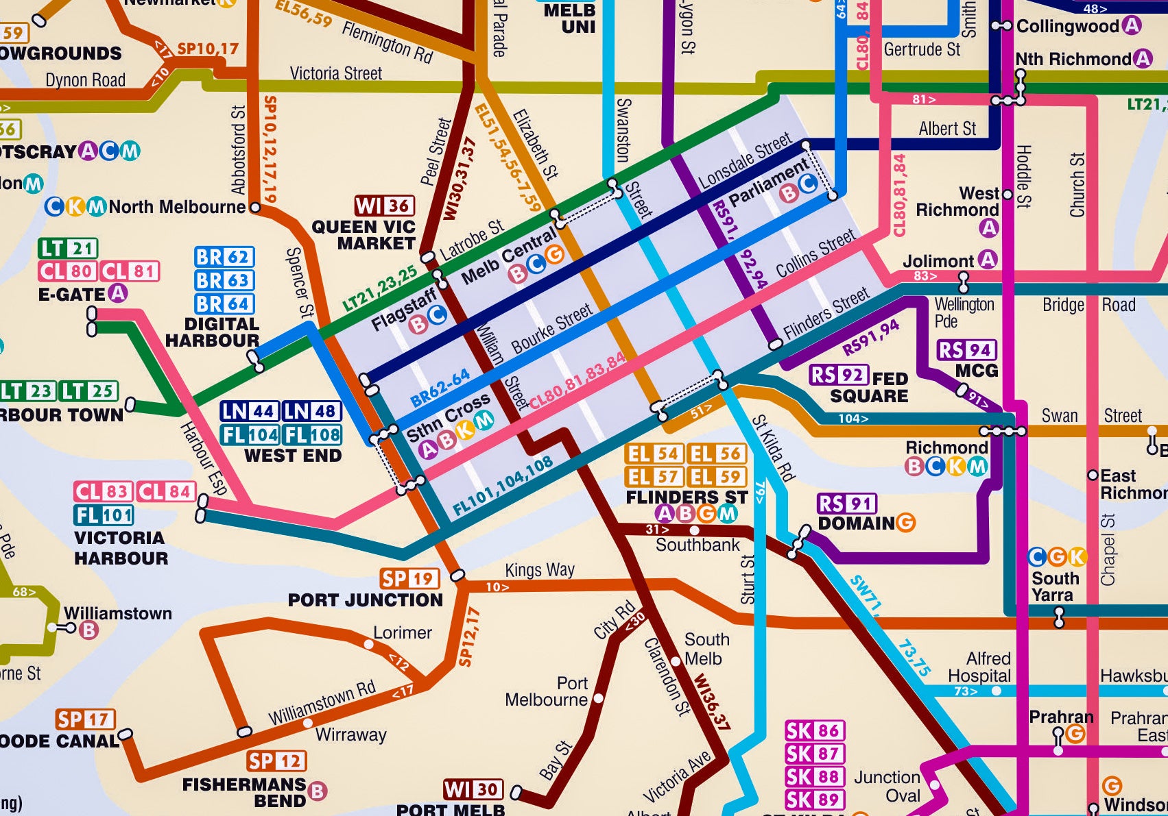
My 2048 vision is a fairly faithful future interpretation of the 1923 proposal, with some notable differences. - the 1923 map showed the location of the tracks, but if I were to look at a map showing the current tram lines in Melbourne without the context of routes, it would be fairly difficult to work out where the routes were meant to begin and end. That’s what I have attempted to do, using some knowledge and logic of how people in the present day tend to move around the city. A lot of the routes feed into the CBD, but there are a few cross-town routes connecting activity hubs

(Image: a 1950's map used to help flesh out potential routes)
As it sits in the same universe as the 2047 map, future stations and icons for the rail network exist in my 2048 tram map. I used colours more reminiscent of some of the tram maps seen in the 1990’s, with different colours and route numbers based on the CBD street it travels through, or suburb the route originates from.

In addition to the 1923 proposals, I also incorporated some of the extensions proposed by The Greens in 2014. Since then, there have been quite a few further proposals that I’ll incorporate into a new map as part of a “modernisation” project I’m working on with some of my old maps, to get them in an A3 format and with a bit more polish.
As with my other fantasy transit maps, the most fun and intrigue comes from looking at the map and thinking about what could have been if history played out differently. Who knows, maybe the year 2048 will see a deserved boom in tram infrastructure.